Major developments in drones, satellites and other data sources have transformed the imagery and earth observation industry, compared to how it was just a few years ago. Fuelling the growth of highly accurate digital representations of the physical world, these innovations offer the data analytics community an essential part of any progressive information management strategy.
New insights
From site monitoring to change detection, identifying spatial patterns or object detection, this sector is helping users perform analysis, create new insights and make better decisions. Esri UK is experiencing a 20% growth year-on-year in the amount of analytics being performed on imagery data. Industry use is varied and ranges from disaster response and environmental projects to urban planning, transportation and agriculture.
Real-time monitoring
Commissioning satellite imagery or drone flights was previously expensive, while mobile scanning did not even exist until recently. Today, it’s possible to task a satellite to capture imagery of your chosen area and receive images in just over an hour. While for more detailed data, fleets of drone-in-a-box solutions can be instructed to automatically fly to a site anywhere in the UK and send hi-res images even more rapidly. Obtaining imagery data this quickly into a GIS means near real-time monitoring of places is now possible. For example, port operations or crop growth can be tracked more closely.
AI and digital twins
For large scale projects, AI is creating more timely and accurate land cover maps of the entire planet, which help organisations understand and track land use and better manage resources. Advances in processing power are making 3D models of whole cities or even countries possible, by fusing together terabytes of imagery data to make photo-realistic scenes. These provide the foundations for building digital twins.
Tools to analyse imagery are making things easier for the data community, including using AI models to spot patterns, trends or automate object detection. Pre-trained models give users an easy route to most types of recognition tasks. This might involve identifying suitable roofs for solar panels or spotting a specific species amongst thousands of different animals. Automated workflows are also available for quantifying change in 3D imagery, which makes it easier to identify variations over time. This is being used for managing aggregate stockpiles and shipping container stacks.
What we are seeing overall is the democratisation of imagery data. The barriers of cost and accessibility of imagery are coming down, while the resolution and frequency keeps going up.
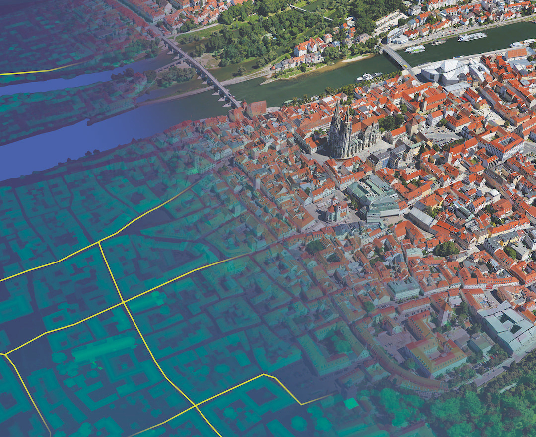
Digital twins at country scale
Digital twins are becoming a critical tool. To be effective, they rely on highly accurate and current 3D models, derived from different types of imagery. Esri’s new ArcGIS Reality provides the reality capture or ‘reality mapping’ software needed to deliver these models.
Modelling construction sites, cities and even whole countries traditionally needs a lot of technical skill, specialist software and a huge amount of data editing, manipulation and integration. The arrival of Esri’s ArcGIS Reality means that aerial, drone or satellite imagery can now be quickly transformed into valuable content, including highly accurate 3D models of facilities, cities and even whole countries. These stunning images or 3D maps are then layered with geospatial data to enrich reality with greater context.
High-end cloud processing of multiple terabytes of imagery data is what makes this possible.
This innovation dramatically changes things as it automates much of the work involved in handling the images, achieving reality mapping more quickly and at lower cost. ArcGIS Reality has advanced traditional GIS into the 3D space, at any scale and any extent.
This is opening up new possibilities for how and where these large-scale digital models can be used, in both the public and private sectors. In oil and gas, for example, long distance pipelines which might span countries can be easily mapped and modelled in 3D, while in smart cities and urban planning, users can accelerate the adoption of digital twins to gain a deeper understanding of their physical assets. The market for reality mapping is only going to keep growing because digital twins need highly accurate 3D models as their foundation.


Keeping track of planet Earth
Developments elsewhere include large scale datasets covering the surface of the whole planet. Using AI, the Earth’s land use is being classified using satellite imagery far quicker than previously possible – the whole globe can be completed in days, not weeks. These more timely land cover maps help users in many industries and developing nations understand and track land use and how to better manage resources.
Esri’s global land cover map shows the planet according to land cover type, revealing urban areas, grass, trees and crops, among others. This improves understanding of important challenges such as food security, land use planning, surface water and resource management. In addition, national government resource agencies use land use/land cover as a basis for understanding trends in a country’s natural capital, which helps define land planning priorities and is the basis of budget allocations.
A snapshot of this data reveals that Los Angeles is one of the cities with the highest percentage of built area in the world with 88%, while London is one of the world’s cities with most grass cover at 11%.

Catastrophe planning with drone data
Lincolnshire Resilience Forum (LRF) has introduced new techniques using drone imagery to help it better prepare for emergencies across the county, including flooding, loss of critical infrastructure, pandemics or severe weather.
Covering over 2,000 square miles and a population of more than 750,000, the LRF’s objective is to protect human life and contain emergencies. Lincolnshire has one of the largest single landmasses in the country at risk of tidal inundation, along with Europe’s highest density of static caravans at more than 34,000. Identifying static caravans is traditionally difficult due to licensing regulations, land ownership and registry data.
Now with new deep learning tools available, the multi-agency partnership is developing ways of using image recognition to reveal where previously unknown caravans are.

This speeds up the identification of caravans using drone and satellite imagery, to gain a more accurate understanding of where residents need to be evacuated from in the event of a major flood.
Esri software is also making aerial data capture faster and more accurate to create 3D digital twins of potential higher risk zones, supporting a better understanding of access and evacuation points. The project means the LRF can create digital twins more quickly, particularly for Control of Major Accident Hazards (COMAH) locations, which involve dangerous substances such as gas and oil refineries.
Sharing imagery across the National Trust
The National Trust uses Esri’s ArcGIS Online to improve how it shares its imagery data, including lidar, aerial photography and drone content, bringing it all together in one place and making it more accessible through various applications and devices. Staff use a variety of data to assess landscape change over time and imagery is an essential part of this work.
Previously, workflows for processing and sharing remotely-sensed data had been manual and time-consuming. The new system provides imagery hosting, streaming and advanced analysis capabilities in the cloud, providing more efficient access across the entire organisation.
This works well for the National Trust, an organisation with 12,000 staff and 46,000 volunteers with different skill sets as it meets every user’s needs. From individuals who are not familiar with imagery or GIS and simply want to view a map, to more experienced users who need to carry out more complex analysis.
Overall, the system supports the transfer of knowledge in an easy and effective way, building a better understanding of archaeology sites, landscapes and properties which help to preserve them.

Democratisation of imagery data
Simplifying access to imagery and the tools to analyse it is helping a wide range of organisations propel their understanding of the world around them. Supporting data-driven decision-making, GIS allows users to analyse imagery data in context and share the outputs more easily than ever before – the days of imagery being a standalone discipline are long gone.
The future of this rapidly evolving technology is bright – the examples above are just the beginning. The next wave of applications will include immersive experiences where AR and VR allow users to interact with 3D models, while AI will be put to work processing more imagery on a global scale.
Esri UK is at the forefront of harnessing the power of imagery to give an unprecedented view of the world. And with the barriers to adoption being constantly lowered, soon many more organisations are set to benefit from looking at the planet in new ways.
For more information on Esri UK’s imagery solutions please visit:
https://www.esriuk.com/en-gb/arcgis/imagery-remote-sensing/overview
Read more
What generative AI means for business analytics – Jim Goodnight, founder and CEO of SAS Institute, tells Information Age his thoughts on the impact generative AI will have on business analytics